PRESERVING CAPE HERITAGE AND CULTURE THROUGH EXPLORING VISUAL ARTS AND EDUCATION

DIGITAL ARCHIVE RESEARCH LIBRARY:
MITCHELLS PLAIN
BY YUNUS OGIER, OCTH RESEARCHER
[12 minute reading time]


Establishment
The coloured population in South Africa has always existed as an in-between group, neither here nor there, neither white nor black. To contextualize this as an abstract theory, coloureds are essentially the liminal race of South Africa; existing as a go-between of spaces, identities and landscapes. To be an in-between race is one thing, but to be geographically (dis)placed and to amplify that sense of isolation is an evil of a grander scheme.
If the Population Registration Act of 1950 was the bureaucratic architect of social segregation, then the Group Areas Act was its spatial accomplice, only layering the wounds physically of what the Group Areas Act was doing demographically. Mitchell's Plain, the township sitting almost 20 kilometers from the Cape Town city center, is a space that has lived and experienced the severities of the apartheid regime.
The decision to establish a new township within the Cape during the apartheid era was formulated around the need for housing for the coloured community. The census data for 1970 stated that out of the 21 million South Africans, coloureds comprised 9.4 % (whites were 17.3%), however, within the south western cape alone, coloureds made up almost 61% of the population group in the region. In 1971 the government gave the Cape City Council (now the City of Cape Town Metropolitan Municipality) the go ahead to start planning Mitchells Plain. To assess what land was available for the relocation of persons under the Group Areas Act, surveys were undertaken in the area and showed that 3100 hectares of land was available on the property called Mitchells Plain. The irony is not lost, as initially this land was earmarked for whites in a 1966 advertisement by the Department of Planning (Pessoa 2023:19). The naming of the land was equally intentional, or as intentional as it was for the apartheid regime to solidify a legacy of white personalities onto non-white allocated land. According to sources, the township was named after Lieutenant-Colonel Charles Collier Michell who was the first surveyor general of the Cape of Good Hope. Essentially Michell (Mitchell) documented, mapped, demarcated borders, all on a landscape that was colonized by the British. This was clearly not lost on the National Party's interests, and the transposing of one colonizer onto another colonizer's housing projects was only a way to indirectly assert their ideology.
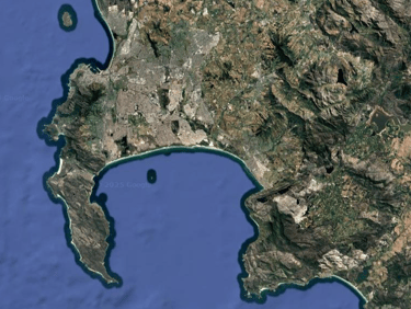
Satellite image of the False Bay coast showing the densely built up areas within the Cape flats

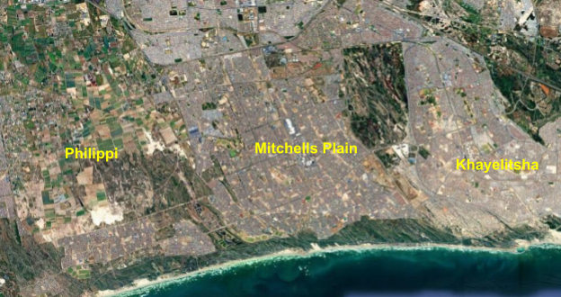
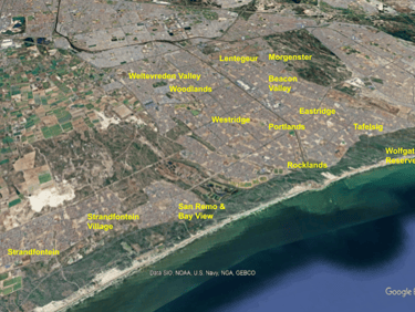
Satellite image of Philippi, Mitchells Plain and Khayelitsha.
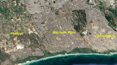
An aerial view of Mitchells Plain taken from the south west
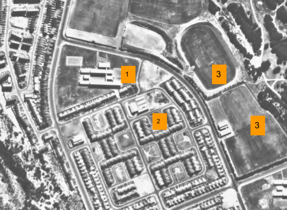
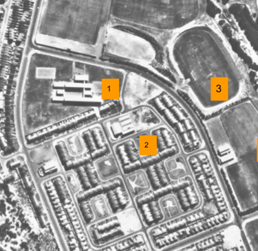
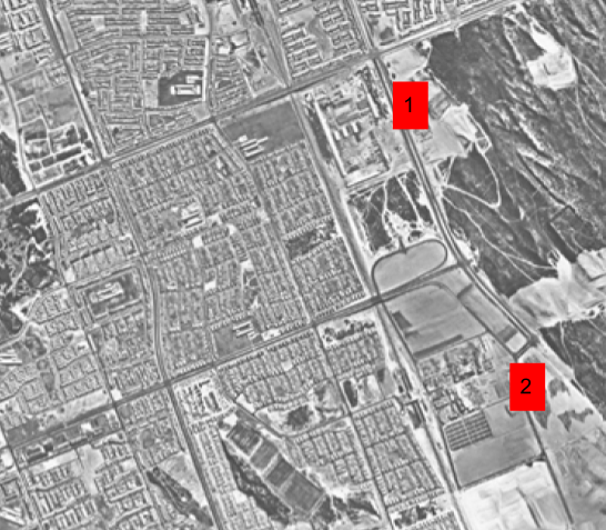
Aerial photograph of Westridge in 1980 Source: City of Cape Town, Map Viewer
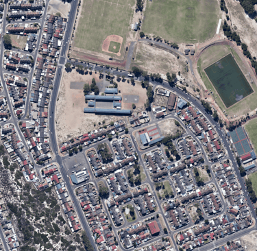
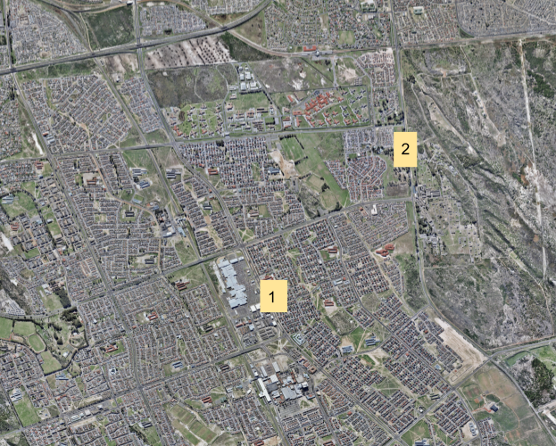
To understand just how rapid the inception and construction of the township was; the following time line will underscore key structural milestones. In November 1974 the first planning phase was initiated with construction starting on Westridge in 1975. By April of 1976, Mitchells Plain was formally opened by then Prime Minister John Vorster with the first families moving into Westridge. Gleaning over the aerial photographs of the early 1980’s of Westridge, there is clear evidence of a well designed neighborhood. Mitchells Plain Primary school (no.1 in the image below) was built within the suburb, and in its early days staffed only eight teachers when it welcomed the 216 pupils on the 5th of October 1976. Accompanying the school was the St John’s Bosco Catholic Church (2) and the Stephen Reagan Hall and sports field (3).
This suburb, with its west facing direction, perfectly looking towards the Muizenberg mountains, was the poster child for Mitchells Plain and sold as its “Arcadia” - the idyllic town where its inhabitants are in harmony with its surroundings. Theresa Solomon, who was mayor of Cape Town from 1996 to 1998 moved to Mitchells Plain in 1976, and stated that “people were urged to move” and to come live in “the city by the sea”. Solomon was instrumental in the fight against apartheid and became one of the founding members of the UDF during its infancy.
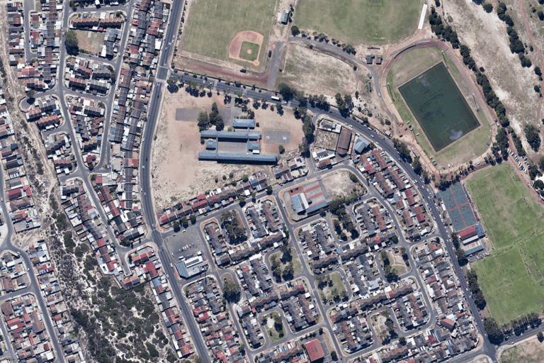
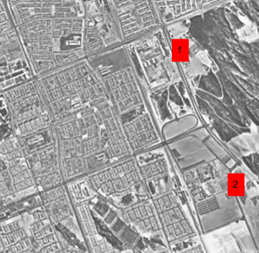
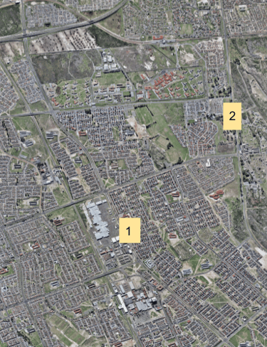
Aerial photograph of Westridge in 2024 (Source: City of Cape Town, Map Viewer)
Compass
All photographs/satellite images are on a North - South axis
Institutions of power are eager to let the world know what infrastructure or social projects they have in the works to leverage their power and legitimize their rule. Think of Mussolini's fascist Italy, where the building of roads, hospitals and schools all coalesced into a performative display of organization and ambition. Mitchells Plain therefore was akin to the Nationalist Party’ “wunderkind”, a “model township” if ever there was one to represent South Africa on the world stage. By showcasing that they could mobilize, house, and provide facilities for a community they did not see as equal, only amplified the “good” the National Party was doing for the country. Slowly the suburbs within Mitchells Plain started to emerge, with its footprint encroaching across all cardinal points.
In 1989, just a little over a decade from its conception, the following neighbourhoods were showing promising numbers.
Area: No. of units:
Westridge 4042
Portlands 4562
Lentegeur 5247
Rocklands 4951
Woodlands 363
Strandfontein 961
Tafelsig 3426
Eastridge 2841
Beacon Valley 3634
Flats 1433
New Woodlands 3100
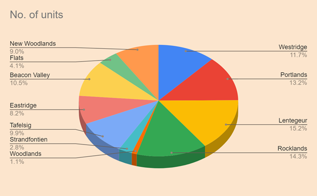

From the table it is clear that, even though Westridge was the first suburb created in Mitchells Plain, it was not the fastest growing. Lenteguer, which is situated on the eastern side saw the highest number of households in 1989, followed shortly by Rocklands. The first healthcare facility to open was the Mitchells Plain Community Health Care (CHC) which was opened on the 1st July 1986 in Eastridge and had to serve the surrounding population. The center only received its first emergency unit in 1993, only 7 years after its opening.
Then there were the subtle economic aspects of such a large number of people in a concentrated area. In 1989, the Mitchells Plain Taxi Association brought forth a concerning matter involving other operators from the surrounding suburbs encroaching on Mitchells Plain commuters. Individuals (taxi operators) started to obtain permits from the Road Transportation Board and then started to hire out these permits to drivers not within the Mitchells Plain area, essentially allowing other taxi operators to monopolize on the needs of commuters to be transported. This showcases the level of organized crime already prevalent within the area, but also speaks to the wider socio-economic hardships being witnessed on the Cape Flats. The Group Areas act indirectly allowed the fruition of informal public transport, due to the vast number of people being relocated. The knock on effect was the taxi industry which saw fit to gain as much profit as possible in the transport of people to the city center, even if that meant encroaching on other operators' turf.
Even if residents were mobilized in large numbers under the Group Areas Act onto the Cape Flats, this did not mean that their living conditions had to remain stringent, as there was some autonomy in terms of making adjustments to their living spaces. Take for example the following letter sent to the City Engineers in September 1989.
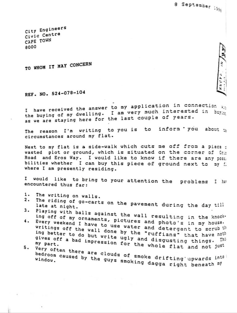
This letter highlights the human dimension of life in the new township and while they were forcibly removed from their previous residences, they still exercised some form of agency in shaping their environments. The writer not only complains about the social problems in the neighborhood such as graffiti, noise and drug use, but he also expresses a desire to purchase and improve the adjacent municipal land. This reflects the wider truth about Mitchells Plain during the 70’s and 80’s; where government houses are not seen as static units meant to restrict its inhabitants, but are homes that residents adapted and personalized. In this manner, the inhabitants are asserting their dignity and stability in a space that was originally a site of relocation.
Visual representation in percentages of number of units in Mitchells Plain in 1989
Geography and Economic Evolution of Mitchells Plain
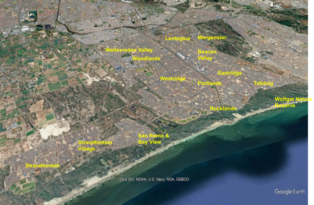
Mitchells Plain is located along the southern False Bay coast and lies between Muizenberg on the west and Khayalitsha on the east and covers a land area of 43.76 km². In its initial phase it was meant to house approximately 250 000 people, however that number was surpassed with the 2011 census showing that the population was 310,485 with 67,993 households. Population growth and the need for services and consumer convenience would have ultimately led to the development of local convenience centers and shopping centers. Even though Mitchells Plain officially welcomed its first inhabitants in 1976, it was not only until the early 80’s that saw the construction of Town Center, along with the railway lines.
Town Center is situated relatively central within the township sitting between Beacon Valley to the east, Eastridge to its south, and portlands and westridge on its western side. However, as the suburbs expanded, it became apparent that more shopping facilities were needed in the area. The early 90’s saw the building of the Westgate shopping center, which in conjunction with the town Center managed to alleviate some consumer pressures. Fast forward to 2003, and another shopping center was nearing completion just north of Town Center.
The Liberty Promenade (formerly The Promenade) became the newest addition to the Mitchells Plain landscape. In the span over just over 20 years, the township had grown so exponentially that it needed more consumer establishments to cope with the growing demand. The following images provide a very clear illustration of the rapid expansion of the township starting with nothing but barren, sandy terrain in 1973 to the densely populated landscape of the early 2000’s.
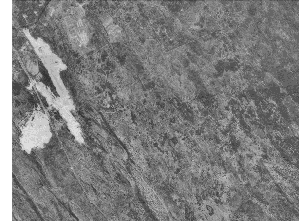
Mitchells Plain 1973
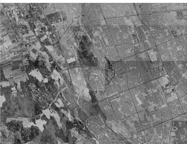
Mitchells Plain 1980
The aerial photograph (above) of the township in 1980 clearly outlines the ambition the apartheid government had in mind for the coloured community. In just four years an area of 14 square KM saw massive construction projects, including the building of Town Center and the railway lines.The planning and building of the township may have seemed ingenious to the outside world in apartheid era South Africa, but within these highly engineered projects, the ultimate goal was to orchestrate a township that was somewhat autonomous. In its autonomy, it was able to function within its bubble suitably away from the CBD and the white areas, thereby allowing physical engineering to coincide with social engineering.
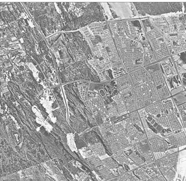
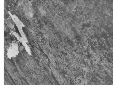
The close up aerial photograph shows the site where the Liberty Promenade will be built in 2003 (1). To the south is where Mitchells Plain Town Center is (2) with the railroad on its west.
Close up of 1980 aerial photograph. Source: City of Cape Town, Map Viewer
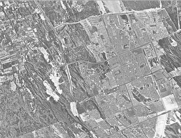
The mid 90’s were still seeing expansion projects. The aerial photograph below, taken in 1997 only adds on from what was being built in the late 80’s and early 90’s. Westgate Mall is visible just to the right of Philippi farms with the vacant lots of Rondevlei still awaiting its new occupants.
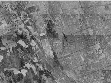
Mitchell's Plain 1997 Source: City of Cape Town, Map Viewer
The 2000s ushered in a new era for the ever evolving township. This time its reinvention was urban renewal. The township was listed as an urban renewal project (URP) in 2001, which meant that key sectors within the Mitchells Plain were identified as markers for economic development and growth. In short, it was a way for the CoCT to pay necessary attention to an area that started to take strain under its own weight. However, beyond the continuous projects and policies that governed the area, Mitchells Plain remains more than a case study in urban planning.
Mitchells Plain is a place born from displacement, a landscape that carries the scars and untold stories of the thousands of inhabitants who traverse its streets daily. By being pushed to the outskirts of the city, the residents of Mitchells Plain have managed to build up community, culture and identity through hardship. In this way, Mitchells Plain mirrors the coloured experience, always in-between, always negotiating survival and belonging, but actively refusing erasure. The story about Mitchells Plain is not only about isolation, but of endurance and continuous transformation in the unyielding claim to occupy a space in South Africa’s future.
Mitchells Plain in 2006 with Liberty Promenade (1) and expanding projects in Lenteguer (2). Source: City of Cape Town, Map Viewer
Discover
Contact Us
Our cultural heritage matters
Help us learn and grow by sharing your respectful feedback on our website, exhibitions, social media and more:
Store's Terms and Conditions